Herbert Gottfried
Excerpts from 42 30 North
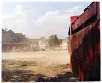
Lines of latitude rarely impinge on our everyday experience. Most of us recognize them as a set of east-west lines on a map, coordinated with lines of longitude to create a spatial system useful in ascertaining locations. The lines have a history of application in cartography, and an equally rich record of use in the affairs of societies preoccupied with discovery, enterprise, empire, war and the occasional human folly. Today, a line of latitude or longitude can be seen as a tool with which to document a cultural landscape and its environmental systems. A Line on the Land: 42.30N and the Massachusetts Landscape is that kind of project–a collaboration by Frank Gohlke, a photographer, and Herbert Gottfried, a poet, to recreate a line across a state. One minute of latitude is a mile wide on the ground, thus 42.30N is 1 mile by 155 miles of landscape, from the Marblehead Neck on the east to Berry Mountain on the west. We drove, walked, and even paddled across Massachusetts using a hand-held GPS device to locate the latitude. Once in the line, we explored that mile, responding independently to what we found. Our intent was to make the abstraction real by juxtaposing the image and poem across the land.
Herbert Gottfried is a poet and Pofessor Emeritus in the Department of Landscape Architecture at Cornell University, where he cunducts cultural landscape studies.